Estuaries - Where a river meets the sea.
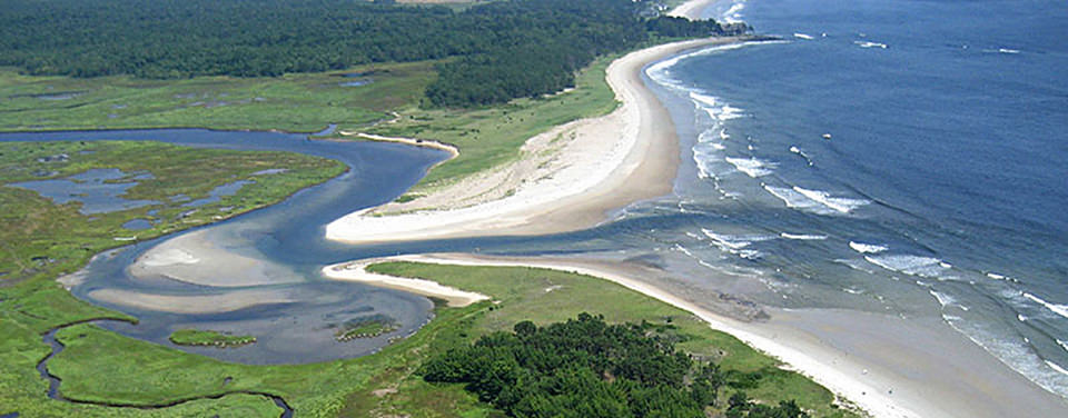
What is an estuary?An estuary is a partially enclosed body of water, and its surrounding coastal habitats, where saltwater from the ocean mixes with fresh water from rivers or streams. To learn more go to... NOAA - What is an estuary?
Types of EstuariesEstuaries can be classified by the geological features that make them up. Click to learn more and watch animations on each type of estuary.
Water Chemistry in EstuariesDissolved Oxygen, nutrient levels (like the nitrogen and phosphorus necessary for plankton growth), and salinity are all highly variable in estuaries. The variation of each of these is based on several factors such as:
A rich array of habitats surround estuaries. The type of habitat is usually determined by the local geology and climate. Habitats associated with estuaries include salt marshes, mangrove forests, mud flats, tidal streams, rocky intertidal shores, reefs, and barrier beaches.
To learn more check out: The Economics of EstuariesEstuaries, have historically provided the focal point around which coastal communities grew up. Most of the worlds largest cities have been build on estuaries. These early developing towns and cities took advantage of the food availability, effective waste disposal, and high quality of life that estuaries provided. Today, estuaries are a tremendous economic resource which provides jobs and resources to coastal communities. To learn more check out NOAA: Why estuaries are so important. Also consider the following:
Across the nation, habitat loss looks like this:
What is an estuary?An estuary is a partially enclosed body of water, and its surrounding coastal habitats, where saltwater from the ocean mixes with fresh water from rivers or streams. To learn more go to... NOAA - What is an estuary?
Types of EstuariesEstuaries can be classified by the geological features that make them up. Click to learn more and watch animations on each type of estuary.
- Coastal Plain -Formed as the glaciers receded in the last ice age and saltwater penetrated river valleys, they are also known as drowned river valleys.
- Tectonic -Significant tectonic movements can lead to the formation of a large depression or basin. As sea water floods in it will meet up with inflowing streams forming an estuary.
- Bar Built - Bar-built estuaries are formed by the accumulation of sediment around the mouth of a river. They can occur when sandbars or barrier islands are built up by ocean waves or by the deposition of river sediment at the mouth of the river.
- Fjord -Typically long, narrow bays with deep walls that have been cut out by the advancement of Glaciers.
- Salt wedge - found at mouths of large rivers (e.g., Mississippi), the large fresh water influx "holds back" salt water at depth creating a salt wedge, little fresh and salt water mixing
- Partially Mixed - deeper than well mixed, more shallow than Fjord, good fresh and salt water mixing, salinity changes both horizontally and vertically, big tidal influence
- Vertically Mixed - typically shallow with strong tidal influx of salt water, extensive mixing of salt and fresh water, uniform salinity from top to bottom, water gets saltier the closer you get to the mouth of the estuary
- Fjord - Deep, highly stratified water chemistry, fresh water flows out at surface, salt water flows in at depth, little mixing of fresh and salt water, anoxic conditions at depth
Water Chemistry in EstuariesDissolved Oxygen, nutrient levels (like the nitrogen and phosphorus necessary for plankton growth), and salinity are all highly variable in estuaries. The variation of each of these is based on several factors such as:
- Freshwater input
- Tidal range (Video of tidal fluctuation in Katchemak Bay, AK)
- Bottom Topography
- Seasonal Variations
- Pollution from estuary watersheds (image from Wikipedia)
A rich array of habitats surround estuaries. The type of habitat is usually determined by the local geology and climate. Habitats associated with estuaries include salt marshes, mangrove forests, mud flats, tidal streams, rocky intertidal shores, reefs, and barrier beaches.
To learn more check out: The Economics of EstuariesEstuaries, have historically provided the focal point around which coastal communities grew up. Most of the worlds largest cities have been build on estuaries. These early developing towns and cities took advantage of the food availability, effective waste disposal, and high quality of life that estuaries provided. Today, estuaries are a tremendous economic resource which provides jobs and resources to coastal communities. To learn more check out NOAA: Why estuaries are so important. Also consider the following:
- Estuaries produce more food per acre than the most productive mid-western farmland;
- 75% of commercial species depend upon estuaries for their primary habitat, spawning grounds, and nursery areas
- 86% of recreational fishing trips occurred within 10 miles of the shoreline;
- The tourism and recreational industry growth produced by the 180 million Americans who visit estuary and coastal waters each year (1993 figures);
- In just 6 states, tourists spent over $105 billion during their 1994 visits; and
- The consumer expenditures on seafood, which totaled $38 billion in 1993.
- To read more go to: http://www.estuaries.org/
- Habitat: Tens of thousands of birds, mammals, fish, and other wildlife depend on estuaries.
- Nursery:Many marine organisms, most commercially valuable fish species included, depend on estuaries at some point during their development from egg to adult.
- Productivity: A healthy, untended estuary produces from four to ten times the weight of organic matter produced by a cultivated corn field of the same size.
- Water Filtration: Water draining off the uplands carries a load of sediments and nutrients. As the water flows through salt marsh peat and the dense mesh of marsh grass blades, much of the sediment and nutrient load is filtered out. This filtration process creates cleaner and clearer water.
- Flood Control: Porous, resilient salt marsh soils and grasses absorb flood waters and dissipate storm surges. Salt marsh dominated estuaries provide natural buffers between the land and the ocean. They protect upland organisms as well as billions of dollars of human real estate.
Across the nation, habitat loss looks like this:
- Puget Sound - 73% of the original salt marshes have been destroyed;
- Narragansett Bay - 70% of salt marshes are being cut off from full tidal flow and 50% have been filled;
- San Francisco Bay - 95% of its original wetlands have been destroyed; only 300 of the original 6,000 miles of stream habitat in the Central Valley support spawning salmon;
- Galveston Bay - 85% of seagrass meadows;
- Louisiana estuaries - continue to lose 25,000 acres annually of coastal marshes, roughly the size of Washington, DC;
- Hudson-Raritan Estuary - 75% of the original tidal marshes have been destroyed in both New York and New Jersey, and 99% of New York's fresh wetlands are gone;
- Chesapeake Bay - 90% of seagrass meadows were destroyed by 1990; in 30 years (1959-89), oyster harvest fell from 25 million pounds to 1 million;
- Long Island Sound - More than 40% of the Sound's tidal wetlands have been destroyed;
- Gulf of Maine - Since 1975, developed land in the lower watershed has doubled;
- North Carolina Estuaries - The state has lost more wetlands than any other state from 1973 to 1983; and
- Tampa Bay - 80% of seagrass meadows destroyed.
Questions to Research:As always you may find your textbook quit handy in answering these questions.
- What is an estuary? Write a description of an estuary in your own words?
- List the four types of geologial estuaries.
- Take a virtual fieldtrip to the Providence River Estuary. Click on the link for the Pomham Rocks site and create a graph (using three colors) or three graphs (using one color) comparing depth to DO (disolved oxygen), temperature, and salinity. You will need to click on the link for "water reading sensors." Write a two sentence summary for each graph giving your best explanation of why these factors change with depth.
- Go back to the virtual fieldtrip of the Providence River Estuary. Click on the link for South Prudence. Follow the same instructions as in question number for. Create and explain graphs for what happens to DO, temperature, and salinity as you go down in depth.
- Create a chart that compares and contrasts mud flats, mangroves, and salt marshes based on at least three characteristics. (think about geology, biology, locations, etc.)
- When exposed to salt water most trees die (think of all the dead trees near Girdwood - they were killed by saltwater a influx during the 1964 earthquake). Magrove trees are different. They thrive in the warm salt water of tropical estuaries. As such they are increadibly important to the stability and productivity of tropical estuaries. Explain how is it that mangrove trees thrive in soils that are very low in oxygen and inundated with salt.
- Explain three reasons why estuaries are so ecologically important.
- Explain three reasons why estuaries are so economically important.
- Based on what you have learned about ecological role of estuaries explain why there has been a big push since Hurricane Katrina to re-build the estuaries and wetlands along the coast of Louisiana.
- In our coastal states, more than half (roughly 55 million acres) of wetlands have been destroyed. Because of the on going threats discussed above, restoration has been a priority. Explain what the National Estuarine Research Reserve System (NERRS) is and the goal of the Estuary Restoration Act (ERA).
